Trans-Mexico Part 2 Day #9 Los Tejocotes to Santa Maria Tatltepec
Trans-Mexico Part 2 - Day #9
January 10, 2023
Los Tejocotes to Santa Maria Tatltepec 95km
Start 7:46am Finish 6:42pm
Total Duration 10:56
Moving Time 8:08
Stopped Time 2:49
Ascent 2,010m
Descent 2,916m
Tour Total 723km
Details at: https://ridewithgps.com/trips/110967603
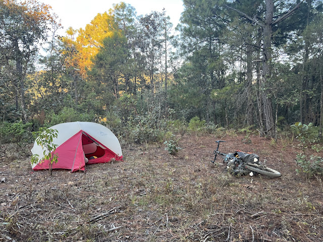
It got really cold last night stealth camping at 8,578'. I had to completely zip the sleeping bag around my head. My feet were chilly, and I kept thinking about my socks and down sweater sitting out in the bike bag. I finally draped my cycling jacket over my feet and took a sleeping pill. I had vivid dreams, which is how I know that I slept. It was freezing when I got up, and there wasn't any condensation on my tent. It still had cement dust from the previous night. The pack-up was textbook. I donned my leg-warmers and socks, in addition to my jacket and buff. Only two cars passed before I departed. I had picked the perfect campsite.
I began with a steep, chunky climb, heading directly into the blinding sunlight. After a brief downhill, I began to see houses as I entered Los Tejocotes. I came to a paved road and took a right. I stopped at Depósito Rosita for a package of Bimbo Mantecadas, a del Valle Néctar de Manzana, and a liter of water. My extremities were chilly as the downhill continued out of town. The road curved left and I noticed fog filling the valley below. The range here was known as the High Mixtecas. The etymology of Mixtlan (cloudy or foggy land) is made from the term Mixtli (cloud) and the suffix tlan (place).
I passed the pueblo of Canamá and admired the handsome new welcome sign. After a nice downhill I came to a fork. Instead of the road with smooth pavement, I remained on rough chunky dirt. The next town was San Juan Mixtepec, where I stopped at delightful Taqueria Chavez. One woman was cooking while another served drinks and managed the till. I ordered an amazing breakfast burrito with chorizo and eggs, along with a strawberry juice. It was one of my favorite meals, and completely satisfied my appetite. I was able to charge my devices, and complimented the women before leaving. San Juan Mixtepec was a beloved town.
On my way out of town I crossed the one-lane bridge over the Rio Mixteco, and got stuck behind a truck kicking up clouds of dust. I began a steep climb, and stopped to remove my jacket, leg-warmers, and socks. There were mortars being fired in the distance.
I saw a sign that Tlaxiaco was thirty-two kilometers ahead. I knew that today would be a big climbing day. There had been no phone service in San Juan Mixtepec and I later realized that my phone didn't charge. It was still at 53%. I enjoyed a level section, and then it got rough. Not a single cloud was in the sky. The next little village was Independencia Mixtepec, where I stopped for a Fanta. The climb was steep out of town, and I took a break in the shade of a tree.
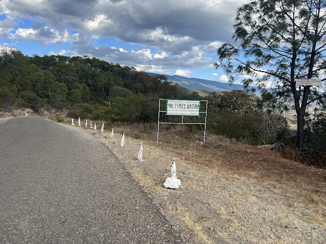
I came to a fork and took a right while still heading towards Tlaxiaco. I was surrounded by small fir trees. There were no fences nor traces of animals or people as I zigzagged across the mountains. The grade mellowed and I found myself in a clearing bathed in sunlight. There were only a few wispy clouds in the sky. I was at 7,450' and then the chunky climbing resumed. I reached another flat section and was protected by the shade of the trees. I passed a steamroller on the side of the road that hadn’t been used in ages. I realized that I hadn't been seeing roadside trash in Oaxaca. I repeated saw 'No Tires Basura' (no littering) signs, and there were roadside trash cans.
At the top of the pass I came to an intersection with a large boulder in the center. It was 11:38am and I was at 8,110'. I began a nice chunky downhill. The road was in bad shape and some of it was steep. I was lucky to be on a gravel bike with fat tires.
Back down in the Rio Mixteco valley I missed a turn and had to climb back up a segment. At the river crossing I got turned around again. Every time I was confused I had to stop and turn on my Ride with GPS iPhone app, which consumed power. The screen on my Wahoo was small and lacked detail. I walked my bike across the Rio Mixteco and thought I was on route. I climbed up rock and gravel on the opposite bank and realized that I was supposed to have crossed the bridge. I was finally back on route. I began ascending and passed a large farming complex with handsome greenhouses. A steep climb on two-track commenced through the trees.
The next section was a grueling hike-a-bike, and I noticed more Spanish moss hanging from pine trees. I took a five minute nap on the side of the road before the next climb. I eventually reached a flat area, and was granted some greatly appreciated cloud cover. After much climbing, I finally rounded a turn. In the distance I could see a small town with a church. I rode through another farming area with log cabin structures and greenhouses.
I was still in the mountains and pulled into Santiago Nundiche. A street market had been set up at the bottom of a steep hill and most of the stalls were empty. I passed a stand selling religious articles. I went to a tienda where I saw tables, and asked if they had food. They sent me next-door to the depósito. A bunch of men were sitting outside at a long table, and I joined them. I plugged in all my devices and ordered lunch. I relished a pork fillet with rice and beans, and a cold bottle of Coke. In addition I got myself a liter of cold water. The guys I was sitting with were curious about my trip, and couldn’t believe how far I’d come. They looked at my map and said that Oaxaca was two hours by car on the main roads and highway. I was taking an off-road route straight across the mountains. When I left, my iPhone was up to 57%. Santiago Nundiche was good to me.
After a steep climb out of town, I enjoyed a nice flat section in the shade of the pine trees. I noticed white painted rocks to either side of the road. There was no litter, and I observed plastic garbage collection crates attached to trees and poles every hundred meters.
I came to a crossroad, and rather than staying on the highway the route led me on more dirt. I climbed straight up a rocky two-track. A taxi passed me while I was hike-a-biking, and the thought occurred to me to flag a ride. I was supposed to have finished today in Oaxaca. Michele would be arriving at 7pm. She had never been to Oaxaca and she didn't speak Spanish. The thought of a bed, a warm shower, and clean clothing was appealing.
I finally came to the high point, and began a bumpy downhill. Eventually I came to highway 125. The guys whom had earlier looked at my map mentioned that I could have taken a paved road to this highway, but it would have been more distance. The steep chunky gravel was the most direct route. I passed young people walking home from school.
There was considerable motor traffic on the highway but the surface was smooth and the slope was mellow. After a few minutes I came to a fork and took a right. There was a store at the corner where I got myself a cold refreshing bottle of Dos Equis. I wish deli beers were 75¢ in Brooklyn. The next town, San Miguel Achiutla was twenty kilometers ahead on asphalt. It was 3:38pm and I planned to make up some time.
I was on smooth asphalt as I flew down into the valley. It was a pleasure to be gliding so quickly. That said, in the back of my mind I knew I'd eventually have to make up the elevation. I rode through Santa Cruz Tayata, and was still at 7,000'. I hadn’t lost that much altitude.
I pedaled through Santa Catarina Tayata and passed a secondary school, basketball court, and beautiful old church. At 4:30pm I finally arrived on the outskirts of San Miguel Achiutla. I crossed a small stream, and realized that I had missed a turn. Rather than continue on pavement, the route veered off-road on dirt, gravel, and chunky rock. I came to a steep hill and began cursing Mark and Hannah. I crossed a dry stream bed replete with gravel and rocks and then persevered a ridiculous steep uphill which I had to hike-a-bike. I finally reached the highway which I rode for a few meters. I passed the ruins of the Calvario church and then began a long steep concrete descent. The route had been more direct than the pavement, but I had lost half an hour and expended considerable energy getting to the center of town.
My plan had been to grab a meal, charge my devices, and hopefully find phone service. The food options on the map never materialized, and I kept pedaling. I'd seen only one open tienda, and later regretted not stopping for water. I was no longer on my printed map section for day seven, and was traveling blind while trusting my Wahoo. I passed a guy with his two dogs and flock of sheep.
I was riding on a rugged, poorly maintained highway. There was a huge cloud system to the west above the mountain range, and I enjoyed a nice downhill section. I was riding south along a wide valley, and could see a small town ahead in the distance. I realized that my sore left wrist hadn't been bothering me. The pain from the rest of my body had drowned it out.
I came to San Bartolomé Yucuañe and stopped at an abarrotes for water, beer, and spicy peanuts. The asphalt surface improved considerably, and everything was coming back into alignment. It was 6pm and the sun was putting on a light show to the west.
At 6:30 I exited the highway and took a left onto a concrete and stone paved road. I was heading up over another ridge, and there was very little motor traffic. It was starting to get dark and I turned on my lights. I needed to find a place to camp. There was a steep rise to my left, and a gentle slope to my right. I was surrounded by scraggily palm trees and scrub. Off to the right side of the road I found a site adjacent to a palm tree. I was at 5,500' and it was noticeably warmer tonight. I set up my tent and enjoyed cold cans of Tecate and spicy nuts. A moth flew into my tent and I had to kill it. I studied my maps and itineraries for the next two days. My Wahoo was at 57%. Michele had just landed in Oaxaca and I was out in the middle of nowhere. I was wrecked.
 |
| Stealth camping at 8,578' |
 |
| Depósito Rosita in Los Tejocotes |
 |
| Delightful Taqueria Chavez in San Juan Mixtepec |
 |
| One of my best meals |
 |
| Broken down Steamroller |
 |
| Spotless Oaxaca roads |
 |
| Ruina del Calvario outside of San Miguel Achiutla |
 |
| San Miguel Achiutla disappointed me |
 |
| Map / Elevation profile |


Comments
Post a Comment