Trans-Mexico Part 2 Day #10 Santa Maria Tatltepec to San Antonio Huitepec
Trans-Mexico Part 2 - Day #10
January 11, 2023
Santa Maria Tatltepec to San Antonio Huitepec 68km
Start 7:29am Finish 6:40pm
Total Duration 11:11
Moving Time 8:00
Stopped Time 3:11
Ascent 2,466m
Descent 1,952m
Tour Total 791km
Details at: https://ridewithgps.com/trips/110963346
It got cold last night and I didn't bother to brush my teeth after the spicy nuts and beer. I climbed out in the middle of the night to water a bush, and then had to poop first thing in the morning. There had been large tree roots under my tent and I managed to sleep between them on my side, while repositioning myself throughout the night. This morning there was substantial condensation on the fly and I had to roll up a soaking wet tent. It was another textbook pack up. I was out of ibuprofen, as I had depleted my nine-day supply.
I bushwhacked through the scrub back up to the road. I was wearing my jacket, socks, and buff. A truck passed as soon as I got back on route. There hadn’t been much traffic last night, and I had been well-hidden in a secluded spot.
The ride began with an immediate climb on the cement and stone-paved road. I had turned off my phone last night in attempt to conserve power. It had been at 43% and was 43% when I turned it back on this morning. A few minutes later it dropped down to 34%. What the hell? I later realized that the Wi-Fi and Bluetooth settings had automatically restarted which must have wound down the battery.
After the climb I had a long swift downhill into the next valley. I was still on smooth pavement. I crossed a bridge and then began climbing again. I rode by a large greenhouse structure, and was passed by a caballero on horseback. A truck then drove by with workers standing in the back who were headed to the fields.
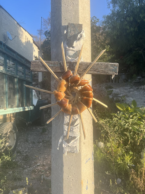
I came to Santa María Tataltepec and the pavement ended. I passed a covered basketball court and four greenhouses. I then rode by an old church, Parroquia de Nuestra Virgen de Asunción, and noticed students who were walking to school. I took photo of a circular bread talisman with twelve radiating wooden spikes hanging against a utility pole. I enjoyed the nice town's pavement before leaving, and then the steep chunky uphill began.
I eventually reached a level section surrounded by fields. There was a stacked stone wall to the left and dried-up corn stalks in a pasture. I passed an old stone cistern and recalled seeing others earlier in the tour. I was riding east directly into the sun.
According to my notes, this morning's stretch would involve areas with property disputes, a washed-out section, and then an overgrown part. I would later be wading across a stream and then going off-route to avoid another wash-out. I continued climbing up towards the pass.
The route was solid two-track with an overgrown center. I rode past an incredible hillside packed with large pencil-shaped cactuses. The next hillside was filled with scraggly palm trees. I went up over the saddle and began descending on chunky rubble. The valley ahead was vast and deep.
I was following a set of power lines, and could see that the track wound it's way to the bottom of the valley. I spotted buildings far away in the distance. It was a rough switchback downhill, and thank goodness I was going down this monster and not up it.
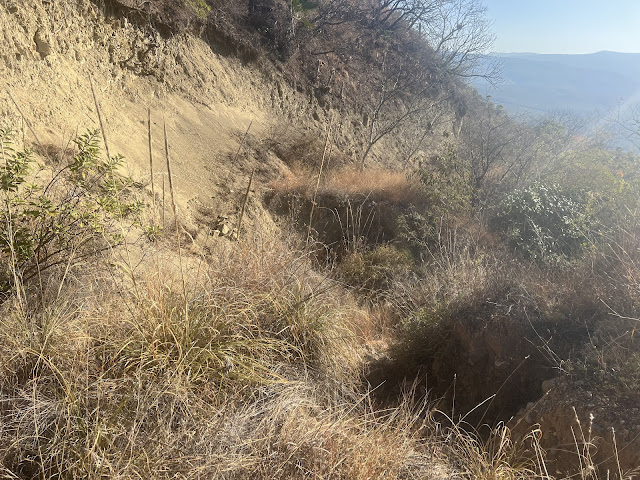
Then I came to the washed-out section. I’d seen a photo of this on the Facebook group. I had to carry my bike across it, but it wasn't nearly as bad as the no-man's land section between Guerrero and Oaxaca a couple days ago. Then the overgrown section began. Because of the wash-out, this area was impassable to motor vehicles. The weeds and scrub had filled in the track, and I could barely tell which way to go. I had to stop several times to look at my phone. I was riding through high grass and couldn't see the ground. I had to trust that I wouldn't hit boulders, large rocks, or ruts. I grunted and moaned my way down the bumpy bronco ride. The road surface eventually improved as I descended, and I was able to pick up speed. Chunky sections reemerged and I had to be careful.
I passed a square metal pylon in the middle of the track, and noticed a parked motorcycle to my right. I was getting closer to civilization. At the bottom of the descent I came to the Rio Verde which would need to be crossed on foot.
The river was only eighteen inches deep, so wading wouldn't be necessary. I removed my socks before crossing in my sandals, and a bull and two donkeys watched. I climbed up the opposite bank and began the post-stream uphill. I followed the river upstream for a few kilometers as I began ascending the other side of the valley. There were rugged sections, but for the most part it was smooth.
There was an upcoming area of steep single-track wash-out that I had decided to avoid. Instead of turning right on-route, I kept going straight. I pedaled out to a two-lane dirt road which had recently been scraped, and the grades weren’t too bad. In the distance I noticed a guy walking alongside the road. It took me a while, but I finally caught him. Eventually I came to the single-track that I had avoided, and was back on route. There was some motor traffic on the road, but it was light. And then the asphalt began. I had been lucky on this valley. I had ridden down the rugged rubble and then up the smooth asphalt.
Ahead in the distance I noticed houses up on a hill, and I was slowly making my way there. A sheep hidden in the bushes startled me with a baa. I slowly climbed up into Yutanduchi de Guerrero as as a Mexican ballad blasted from a nearby house. I passed a small church and a covered basketball court. I asked a man where I could get some food, and he suggested the market. Across from the Palacio Municipal I found several food stalls and sat down at a tamale stand. I ordered one with green sauce and another with molé, along with a bottle of Coke. They let me charge my devices in the stall while I ate. While enjoying my lunch, an official approached me and said that I needed to speak with the authorities. My iPhone was only at 36% when I unplugged it, and I think the cable had a short. I went across the street to the government office and they sprayed my hands at the entrance. Inside I sat down at a table with two women who asked about my trip. They said they just wanted to check in with me for my own security. The sun was now strong, and I put on my arm covers and plugged in a Duane train episode. I rode dirt out of town and eventually re-joined the two-lane hexagonal cast concrete. Motor vehicle tires lined up with concrete tracks and there was stone filler in between. I rode through the welcome arch and took a photo.
The next town was San Pedro Teozacoalco, where I passed an old church and took another photo. I was continuing to enjoy fantastic pavement, and admired another beautiful church, Parroquia San Pedro, in centro. The route took a short-cut out of town on chunky rough dirt. I then rejoined the paved road. I flew down a hill to a bridge crossing and then began a steep ascent. I noticed elegant blue signs for agave groves associated with mezcal production. The distinction reminded me of French wine appellations.
From there it was a steep long climb up towards the next mountain pass. The sun was strong and required numerous water breaks. I eventually found myself back up in the fir trees, where it was pleasant and I could enjoy shade. I tried laying down in the grass for a short nap, but couldn’t fall asleep. I came to construction equipment and guys working on the road. There were cement casting forms laying to the side of the pavement, cement mixers, wheelbarrows, water barrels, piles of gravel and bags of cement. It occurred to me that perhaps the road wasn’t finished ahead. I continued to pass more workers doing incredible manual labor. At 2pm I reached the top of the 6,440' pass.
The finished road ended and I came to the next town, San Miguel Piedras, where there were no tiendas.
There were also no services in the next town of Chidoco. I passed a woman walking with a horse and two donkeys. The animals' front hooves had been tied together, so they couldn’t run away. It seemed cruel, yet the poor beasts were managing.
I rode down into a beautiful valley where I had originally planned to camp on the eighth night. They were excavating gravel alongside the river, and it wouldn’t have been the best place to spend the night. On the other side of the river I began a steep climb up the other side of the valley. I stopped for a few minutes to lay down on an embankment wall. The cool concrete slab felt refreshing. Whenever I laid down on the side of the road, a hawk would begin circling above. I admired how they could tilt and glide effortlessly through the mountain air currents.
I was on dirt still headed up the pass, and I came to a T, where I took a left. I enjoyed a brief descent and then started climbing again through the fir trees. Puffy clouds were forming to the east.
I kept climbing the dirt track and passed a homestead with four amigos sitting out on the porch. Only one of them waved back. I stopped in the shade to open up my reserve liter of water, which I had carried all the way from Mexico City. It was all I had until the top of the pass.
Motor vehicle traffic increased as I got closer to town. Three-wheeled taxi tuk-tuks began passing me going the other direction. A guy on a motorcycle with a cooler and cups passed me going my direction, and I regretted not flagging him down for a treat. Several more motorcycles and pick-up trucks went by. I noticed people in the woods on foot taking a shortcut through the trees.
San Antonio Huitepec was two kilometers ahead and I saw a sign for Oaxaca, seventy-seven kilometers away. It was the first sign I'd seen for Oaxaca, my final destination. The hill was incredibly steep. I rounded a bend and could see the town in the distance at the very top of the ridge. Most of the towns had been in valleys. I was still on dirt, and it was sheer. I was proceeding at a snail's pace. The chevron was motionless on my GPS display, and it kept saying that the ride had paused. I passed two indigenous women in traditional attire who were herding goats. Finally I entered San Antonio Huitepec.
I stopped at the first tienda I saw. I was exhausted and tripped on the door step, landing on the floor inside. I was desperate for water and bought three liters. The town was paved and I immediately got turned around. I had to keep using my phone to navigate. I found a commodore, where I quickly parked my bike and entered. The cooking was being done right inside the door, and the dining tables were in the windowless room in back. Customers were watching a television program as I unpacked my devices and attempted to charge them. The outlet near my table wasn't working and I was directed to another one above a propane tank. I ordered salsa a queso with rice and beans, and a bottle of Coke. There were veggies in the sauce and it was delicious. I was unfamiliar with the dish and had copied another customer's order. I later learned that it was a type of tamale and made the same way. I could have ordered one with meat, but didn't know.
I got turned around again trying to find my way out of town. There was a steep descent and then another steep climb. Soon I was back on dirt. It was 6:24pm and it was getting dark. Finally the well-deserved downhill began.
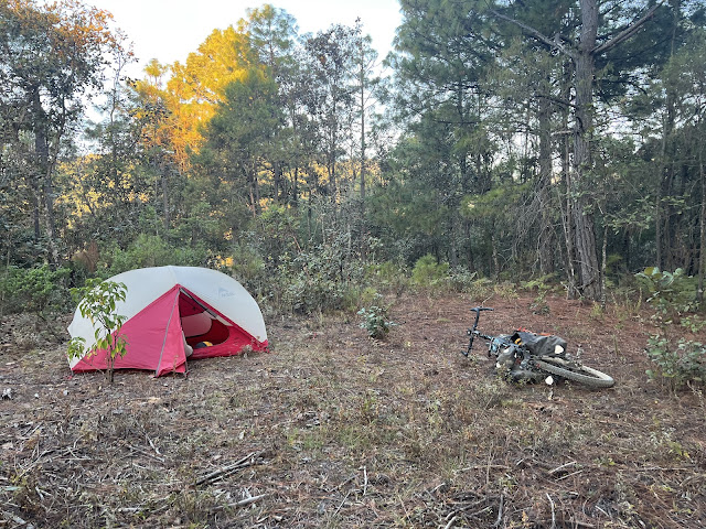
The descent on smooth dirt was beautiful, winding down along the ridge into the next valley. I put on my jacket and turned on my lights. I came to a fork and passed a car that was pulled over on the side of the road. I noticed a field to my left, and turned off my lights and began walking along a trail. I saw level ground under some pine trees a fair distance from the road. Tonight, my last night on the tour, I’d be sleeping on a bed of pine needles. My tent was still drenched from last night, and I set it up in the dark with my stealthy red headlamp. When I crawled into my tent my Wahoo was 55% and my iPhone was at 33%.
 |
| Mixtec bread talisman |
 |
| Wild camping among the palm trees |
 |
| One of many old stone cisterns |
 | |
|
 |
| Hillside filled with scraggly palm trees |
 |
| Washed-out section |
 |
| Overgrown section |
 |
| Overgrown section |
 |
| Crossing the Rio Verde on foot |
 |
| San Pedro Teozacoalco |
 |
| Agave groves for mezcal |
 |
| Building the road by hand |
 | |
|
 |
| Map / Elevation profile |


Comments
Post a Comment