Trans-Mexico Part 2 Day #2 Calimaya de Díaz Gonzáles to Grutas de Cacahuamilpa
Trans-Mexico Part 2 - Day #2
January 3, 2023
Calimaya de Díaz Gonzáles to Grutas de Cacahuamilpa - 93Km
Start 7:46am Finish 4:38pm
Total Duration 8:52
Moving Time 6:04
Stopped Time 2:48
Ascent 1,119
Descent 2,699
Tour Total 197km
Details at: https://ridewithgps.com/trips/110500234
January 3, 2023
Calimaya de Díaz Gonzáles to Grutas de Cacahuamilpa - 93Km
Start 7:46am Finish 4:38pm
Total Duration 8:52
Moving Time 6:04
Stopped Time 2:48
Ascent 1,119
Descent 2,699
Tour Total 197km
Details at: https://ridewithgps.com/trips/110500234
I slept poorly stealth camping in the cornfield out back of Finca Don Enrique a few kilometers down the road from Calimaya de Díaz Gonzáles. My tent was exposed on a central path to the main building as well as from the road. The moon was at half, and it was possible to see my camp could from the building. I could hear motor traffic from nearby six-lane Mexico 55, and people were shooting off fireworks and playing music throughout the night. Because the New Year had landed on a Sunday, today (Monday) was the official holiday. Eventually I took half an Ambien and put in my earplugs, which didn’t do much good. I set my alarm for a 7am, a few minutes before sunrise.
This morning there was heavy condensation in the tent, and my fly was soaked. It was a quick pack up, and I took the direct path back to the road, walking right past the building. I was wearing socks, leg-warmers, shorts, a short-sleeve shirt, a wool cycling sweater, my jacket, and short finger gloves. My fingertips were cold and my toes were chilly, but I didn’t add more layers. It had gone down to 41°F last night and I had been comfortable in my sleeping bag, and silk liner. This morning the sun was low on the horizon as I began pedaling down the highway. I was passed by tractors, delivery trucks, and numerous cyclists and pedestrians. Everybody was starting their day and going to work.
I rode through San Isidro, a small town where inhabitants were out beginning their morning. Collectivos were picking up passengers and dropping others off. Students were on their way to school. The speed bumps were continuing to inflame my left wrist. I cycled right past Piramides Tenago and didn’t see a road sign, so I didn't stop.
The next town, Tenanga de Arista, was charming. Once again, I didn't see a sign and rode right past the entrance to Teotenango, the remains of a pre-Hispanic settlement. I stopped at a juice and liquado stand and had an amazing fresh-squeezed orange juice. Next I got on two-lane Mexico 55 which barely had a shoulder. My rear light and radar were on, and a truck full of pigs passed me on it's way to market. I eventually took a left on a gravel road that paralleled 55 and avoided the motor vehicle traffic. I was circling around Volcan Toluca, which was now to my right. I could see the snow up top. It was a nice dirt track with some chunky parts. I saw a team of guys out working in a field and then I came to a poured concrete downhill that was just as steep as the hill I had to walk up yesterday. At the bottom I made a sharp left turn, and then had to walk back up another hill that was just as sheer.
I rode through San Pedro Zictepec, and then San Juan Xochiaca where the market was open. And then the gravel, chunky dirt, and rock returned. I stopped to turn off my rear light, and remove my leg-warmers and sweater. I hit a jagged rough section and my Salsa Fargo and Maxis tires handled it comfortably. I had to hike-a-bike some of the steep uphill. I got yapped at by a group of white dogs with large black spots. One of them had an aggressive bark, and fortunately no bite. I reached the small pueblito of Santa Cruz Xochiaca, where paving stones and concrete returned. I now had a downhill and could see Malinalco ahead in the valley. It was 10:30am and I had gone 29km.
It was a long descent into Malinalco, the 'Pueblo Magico'. It's association with magic and sorcery is tied to the legend that it was the home the goddess Malinalxóchitl. According to lore, an image of a Black Christ miraculously appeared here, in a cave that was devoted to the god Oxtoteotl. It is the second-most visited shrine in Mexico. Patrick had spent the night in Malinalco. I was now at 5750’ elevation, and stopped at a food stall where I ordered two chicken tacos and one beef. After my meal I removed my jacket, lathered myself with sunscreen, refilled my water bottles, flipped my paper map section and then exited town. Once again I missed the archaeological site, House of the Eagle warriors. I took a right on the two-lane Tenancingo-Chalma highway, heading south through a valley with fast-moving motor traffic and no shoulder.
I took a right on dirt and then went through the small puebla of Puente Caporal. The route detoured from the pavement and I rode a ridiculous chunky downhill that I had to hike-a-bike. A caballero on horseback passed me, as I reached the paved road and then took a right. I was starting to get hot so I pulled over to remove my socks. I climbed up over a small ridge, and then went screaming down a huge steep hill adjacent to two ginormous water pipes. In the Rio Chalma valley I noticed a hydroelectric turbine, the Central Hidroelectrica Alameda. I was now at 4,770'. I crossed the river and climbed up the other side of the valley. I was now on Highway 4, and I missed the turn to El Platanar. Someone had painted 'Ruta de Mezcal' in white lettering on the pavement, and I passed a sign for 'Mezcal el Conejo', or Rabbit Mezcal. I noticed a lot of small places selling Mezcal.
In El Platanar I got turned around. The route did a tight circuit through town and I was trying to follow the small arrow and tiny chevrons on my GPS. The screen was not much larger than a pack of matches. I realized that I was supposed to make a left turn off-road, and I located a single-track running alongside an three-foot wide irrigation canal that was brimming with rushing water. The single-track was a tight balance between the canal and a steep drop-off. I noticed a guy doing concrete work on a elevated drainage slope, and I hollered 'Buenos Dias!'. I then came to an aqueduct. The stonework retaining wall to the left of the canal was twenty-four inches wide, and the wall on the other side was obstructed with a pipe. I always walk with my bike to my right, and my tires were inches from slipping into the rushing canal. I soon found myself in the middle of the aqueduct and over a seventy-five feet above the ground. The tree canopies were well below me. My SPD cleats didn’t offer any grip and I was praying there were no loose rocks. If I lost my balance I was determined to lunge for the water. I focused on getting to the other side, and tried not to think about the height. Finally I reached other side. I continued walking along the stone wall adjacent to the canal, and came to a fork with a gate and massive shut-off valve. Maneuvering around the iron machinery and drop-off with my bike and heavy gear was beyond difficult. A little further along I realized that I was off route. I shouldn’t have crossed the aqueduct, and perhaps should have climbed the concrete slope where I saw the man working. There was no way I was going back over the aqueduct. My bike would be on the drop-off side on the return, and it was just too dangerous. I could ascertain that the route was at the top of a small ridge that I was paralleling. I noticed a trail leading up the hill, so I straddled the canal with my bike. The scramble up the hill was difficult. There was loose scree and I couldn't get a foothold. I was reminded of Fleecer Ridge from the divide this summer, and resigned myself to stripping off my bags and walking everything up separately. Eventually, up on top, I found a corral with horses and donkeys. I sat down to drink some water and catch my breath. There was a dirt road that linked back to the route.
After my navigational blunder I had a nice dirt track with a mellow grade. I was met with a large herd of cattle being driven the other direction. I stopped for a Coke in Colonia Juárez and then rejoined the highway. I left the state of Mexico and entered Morelos, the tour's third state. I rode into Colonia Morelos, and the route took me left on paving stones which eventually came to an end. I then found myself on baby-head chunky purgatory riding down into a valley. And then I was back on pavement.
I took a right on Mexico 166 towards the Grutas (caves) de Cacahuamilpa. At Michapa I crossed over into Guerrero, the tour's fourth state. I rode down into the valley and came to the cave entrance. I knew that the cave closed at 6pm and I wanted to be able to camp there and get food. A food stall let me lock my bike to their wooden post, and I promised to return for dinner. I ran over to the ticket window and booked the day’s last tour. In addition I paid 100 Pesos to camp out back in the parking lot.
The two-hour cave tour was impressive and spanned two and a half kilometers. It was one of the most spectacular caverns I had ever experienced. I felt like I was at the bottom of the Grand Canyon with a stone roof overhead. One of the rooms was called 'the auditorium' and featured seating for concerts and events. The formations were incredible, and the guide pointed out what they resembled. There was the Goat Salon, the Throne Salon and the Cathedral Salon, and there were many elephants, and numerous phalli. He moved his flashlight around one formation to animate shadows that he described as two young lovers. He continued his story while moving the beam of light, and the girl's vigilant mother appeared. The cave was humongous and the tour stretched on and on. I was exhausted. It was dark outside when I exited, and the food stall next to my bike had closed.
I settled on the last remaining stall where I ordered a chicken sandwich along with a couple of Coronas. The staff was tired and wanted to close up. I grabbed a few beers for the parking lot and erected my tent on a concrete slab. It was windy and I had to use my panniers as ballast, along with large rocks for my line tie-offs. Despite the strong breeze, it was much warmer as I was now down to 3580’ elevation. I sat on a plastic chair propped against a tree to drink my beer and attempt to edit this report. A scroungy dog befriended me, hoping that I had something for him. Two security guys stopped by to check on me. I was told that there would be some noise during the night, and that the front gate would open again tomorrow morning at 6am.
 |
| Stealth camping in the cornfield out back of Finca Don Enrique |
 |
| Juice and liquado stand in Tenanga de Arista |
 |
| A roadside mare and her colt |
 |
| Roadside garbage dump |
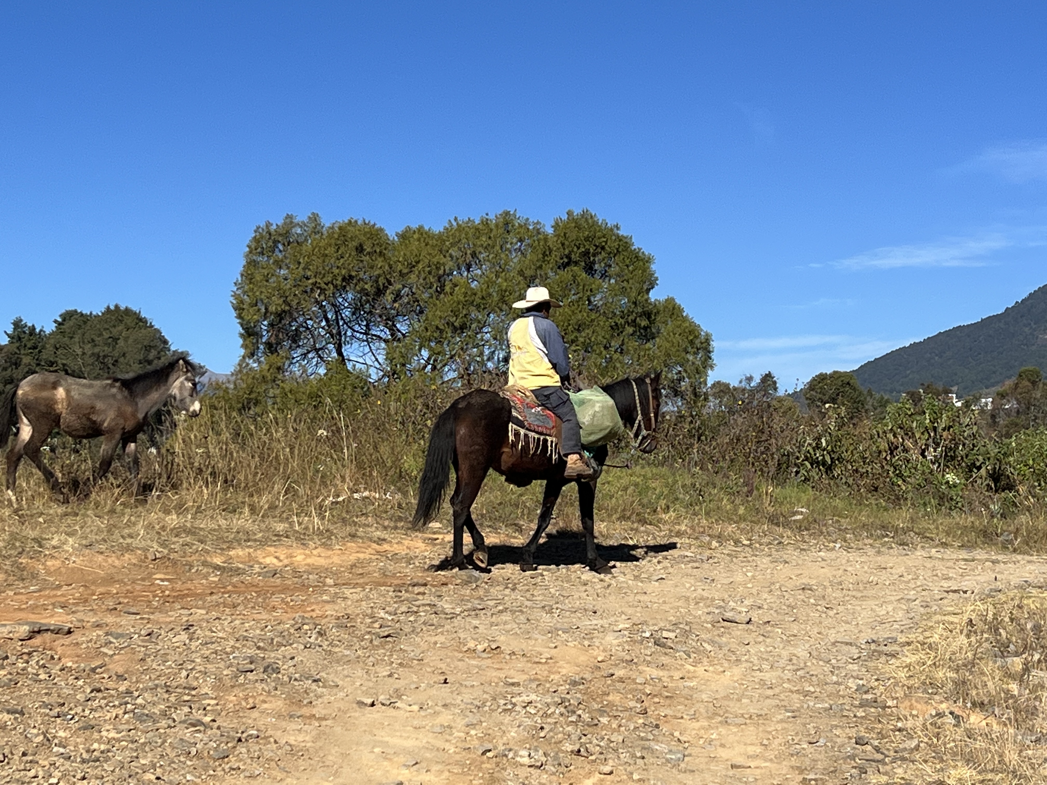 |
| A caballero on horseback in Puente Caporal |
 |
| Amazing tacos in Malinalco |
 |
| Begonias in Malinalco |
 |
| Baby-head chunky purgatory |
 |
| Ruta de Mezcal |
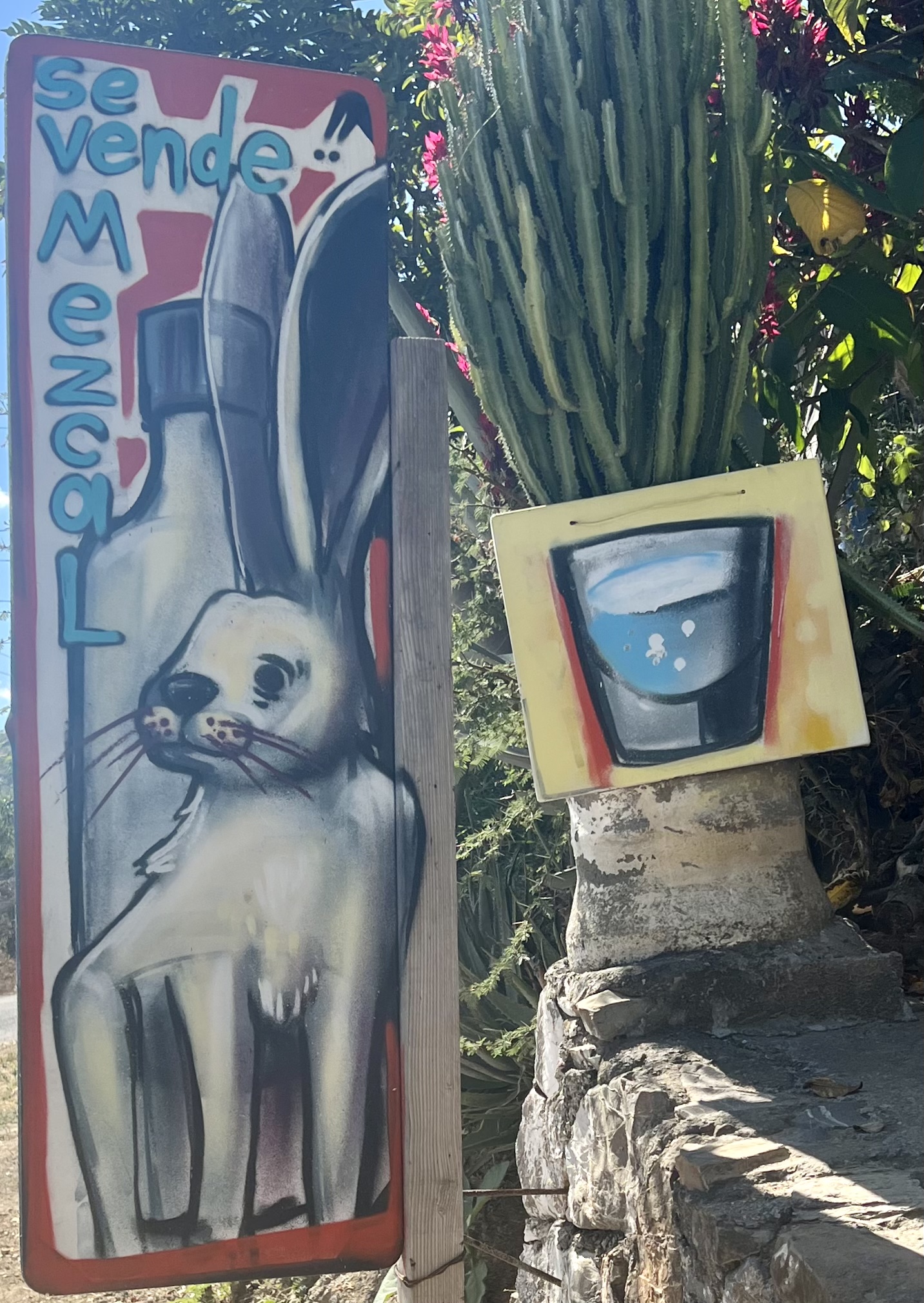 |
| Mezcal el Conejo |
 |
| The aqueduct outside of El Platanar |
 |
| The aqueduct outside of El Platanar |
 |
| Dirt Road outside of Colonia Morelos |
 |
| Grutas de Cacahuamilpa |
 |
| Grutas de Cacahuamilpa |
 |
| Grutas de Cacahuamilpa |
 |
| Grutas de Cacahuamilpa |
 |
| Dinner at Grutas de Cacahuamilpa |
 |
| Map / Elevation Profile |

Comments
Post a Comment